| |
Applies To |
|
|
| |
Product(s): |
WaterGEMS, WaterCAD, HAMMER, SewerGEMS, SewerCAD, StormCAD, CivilStorm |
|
| |
Version(s): |
All |
|
| |
Area: |
Layout and Data Input |
|
Background
The Terrain Extractor (TRex) tool can automatically assign elevations to any nodes (primarily junctions for the water products and manholes for the sewer products) based on the nearest elevations from a draped terrain (contour) file.
NOTE: Tank elevation or level range will not be included with TRex, only the ground elevation.
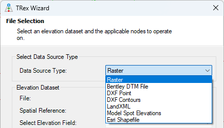
You can access TRex from the Tools menu. Most options are self explanatory, but the most important thing is that the contour must line up with the elements in the model. Meaning, the contour must spatially overlap the model, with both the model elements and the contours in the correct X:Y coordinates. See more further below.
The "Select Elevation Field" is where you choose the field in your data source that contains the elevation values (at the specified "Z Units"). The "z coordinate" option will pick up on the built-in elevation associated with the data source (for example Shapefiles, where the spatial data is built-in). Other fields may show up in this dropdown if you have metadata (attributes/fields) in your data source that contains numeric values. For example you may have a field in a Shapefile to store an elevation, and this field may appear. If you unsure of what to select, you may need to first examine the data source in an external application (for example ArcGIS or QGIS for a Shapefile), consult with the person who provided the file to you, or use the "preview" option in ModelBuilder (for example start a new ModelBuilder run, select the same data source and look at the preview section to see the values in the fields).
If you want to apply elevation data for a selection of nodes instead of the whole system, choose the Selection or Selection Set radials in the section "Nodes to Update". For Selection, it will apply data to elements you have already selected in the drawing. For Selection Set, you can choose a selection set of elements to apply the data.
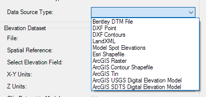
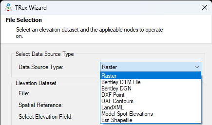
Support File Formats
The terrain / contour file format support depends on the platform that you are using.
Standalone and AutoCAD Platforms
- Raster: Raster image files: .tiff, .tif, .img, .adf, .asc, .dem, .xyz, .grd, .gpkg, .bil.
- Now available in the Standalone platform with version 24.00.03.XX and higher.
- Nearest neighbor and bilinear interpolation sampling methods are used. For more information visit the GDAL website.
- Trex assumes the Raster files only contain one band (elevation) and does not currently support files with multiple bands.
- Bentley DTM File:
- Inroads .dtm
- Geopack .tin (32-bit version only)
- Bentley MX .fil
- DXF Point: points containing elevation (Z) data. Interpolation is used to assign elevations based on proximity to the points.
- DXF Contours: polyline contour data.
- LandXML (.xml): LandXML contour data.
- Model Spot Elevations: similar to the DXF point method but uses the elevation (Z) of spot elevation node elements in the model.
- Esri Shapefile (.shp): point or polyline contour shapefiles.
Esri ArcGIS platform
Additional:
- ArcGIS Raster (note: the Raster DEM support that was added to the Standalone version starting with 24.00.03.XX, will also be available in ArcGIS Pro starting with the v2025 release)
- ArcGIS Contour Shapefile
- ArcGIS TIN
- ArcGIS USGS DEM
- ArcGIS SDTS DEM
MicroStation Platform
Additional:
- Bentley DGN: terrain data contained within the active MicroStation DGN file. Note: terrain data in reference files is not currently supported (must be in the active model)
Model Alignment
Note: When using TRex, it is necessary that the model and the DEM be in the same coordinate system. Usually the USGS DEMs are in the UTM (Universal Transverse Mercator) with North American Datum 1983 (NAD83) in meters, although some may use NAD27. Models are often constructed using a state plane coordinate system in feet. Either the model or DEM must be converted so that the two are in the same coordinate system for TRex to work. Similarly, the vertical datum for USGS is based on national Vertical Geodetic Datum of 1929. If the utility has used some other datum for vertical control, then these differences need to be reconciled.
Add your contour file as a background layer to check if it aligns with the model.
Note: future versions (planned for version 2025) will support assignment of the model coordinate system, to help with alignment.
Protecting Elements that have known existing GPS Survey Elevations
In some cases you may have survey elevation readings with higher accuracy, which should be protected from Trex updates. Here are two approaches to consider:
1) Use ModelBuilder. Maintain a spreadsheet for your survey GPS elevations, linked to the element name and set up a ModelBuilder run for it. After doing a Trex update, click the "build model" button in ModelBuilder for the run you created, to update the Elevation field with the survey GPS elevations (that override the Trex imported ones). You can also create a User Data Extension to flag a node as having a survey-based Elevation, for reference. (see Help topic on User Data Extensions / UDX)
2) Maintain a selection set of elements that exclude the ones that have their elevations from GPS, and use that in the Trex Wizard. One option is to create a query-based selection set, based on a UDX flag field (for example a true/false "From GPS?" field, to only list elements that do NOT have higher-accuracy survey elevations.) Then, select that selection set in the Trex Wizard, so that Trex only updates elevations that do not have the more accurate survey elevations. As you get new survey/GPS elevations, you would update the elevation and toggle the "flag" UDX field, then re-run the query and re-open the selection set to refresh it, so that the Trex Wizard picks up on that change - see related article here.
If you're using the Terrain Model feature instead of Trex (see more on Terrain model below), then you would instead set the node field "Update Ground Elevation from Terrain Model?" to "false" for nodes that have higher accuracy survey/GPS elevations. That way, the elevations for those nodes will keep the higher accuracy values and the terrain model contour will not override.
What if I Have an Image From Google Earth?
The Bentley Civil products can create a terrain model from Google Earth data. If you have access to InRoads or Power Civil for example, you can create the terrain model using that product, as detailed here:
Create an InRoads DTM from Google Earth
This will create a .dtm file, which the Terrain Extractor tool can read, if you choose the Bentley DTM File option as the source data.
Can I Infer Elevations from Surrounding Elements, without a Terrain File?
If you do not have access to terrain data but want to populate missing elevations from surrounding nodes that do have elevations, see the following article:
Inferring ground elevation from surrounding elements
Terrain Model Tool
Starting with the SELECTseries 5 release of the Storm and Sewer products, a new Terrain Model feature has been added, which allows you to activate a terrain model file in the model at all times. Elevations of nodes will then update automatically per the active terrain model, when the nodes are added or moved. For more on this, see the Help topic or the following article:
Using Downstream Trace and Digital Terrain Models
What Method of Interpolation is used by Trex and the Terrain Model Tool?
Please refer to this article:
Interpolation Method Used by Terrain Extractor (Trex)
How can I use data from ContextCapture?
See article:
Consuming ContextCapture production files within your hydraulic model
How can I use LiDAR data?
If your LiDAR data is not already in one of the supported formats (see above - note the additional formats supported in the ArcMap integrated mode), it may need to be processed externally first. For example if it is raw LiDAR data, it may need to be processed into a TIN/DEM, which Trex can then use to assign node elevations. If it is available in raster/image format (for example see here or here), you should be able to use the "ArcGIS Raster" data source type when integrating with ArcMap (available with WaterGEMS, SewerGEMS and HAMMER).
If unsure, contact Technical Support with an example of the data you have, or the file type(s) or any other information about what you have.
Troubleshooting
Wrong elevations with Shapefile source: If you see wrong elevations extracted in the range of 1000 m, e.g. out of a shapefile, then please check if decimal separator symbol set to comma in your windows regional settings, if yes please change it to decimal points and then re-run TRex, it should import elevations correctly then. We have filed a defect for this as of version 10.03.xx.xx, reference number is #1088269, which shall be resolved in future releases of the product.
Nodes get assigned an elevation of zero: first, confirm that the data source aligns with the model. For example if it is a DXF or shapefile, try adding it as a background to see if it overlaps with the model elements. Next check the Elevation field that you selected in the Trex wizard to ensure it contains elevation data. Open the source file in its native application to check if the contours/points near your model node elements do indeed have elevation values for the selected elevation field. For example if you choose a DXF contour file that contains contour polylines in addition to polylines representing the model network, then Trex may try to assign elevations from those polylines since they are closest (if those lines were the source of the model network, imported with ModelBuilder). If this is the case, remove that layer in the DXF first or delete the polylines from the source file before importing with Trex.
Memory-related errors: consider breaking the contour file into smaller chunks. See also: Memory error when using Terrain Extractor
“The active DGN does not contain terrain model data” - This can happen in the MicroStation integrated platform with the Bentley DGN source type. Ensure that the terrain data is in the active DGN model. Trex will not currently be able to read the contour data from a reference file.
LandXML elevations added in TREX or TerrainModel does not match the elevations when opening the LandXML file in Civil 3D: The problem is that it's saving the LandXML file with layers other than the contour elevation lines. After importing the file into OpenFlows products, the elevations of the other elements will be taken into account for interpolation within the TREX or TerrainModel. Civil 3D can differentiate between layers and interpolate only the contour lines, but OpenFlows products cannot. Solution: In Civil 3D, export the LandXML file while selecting only the contour lines (see the screenshot below). Then, import it into OpenFlows.
.png")
Other troubleshooting: see links below or use the search bar above to find other articles in our Wiki
See Also
Trex error: "The data source file must contain at least three unclipped points in order to create an elevation map"
Error when using TRex: No Matching Data: All elements in the model fall outside the scope of the DEM.
Error using TRex - Circular list error clockwise
Error using TREX with LandXML file: "Object reference not set to an instance of an object."